
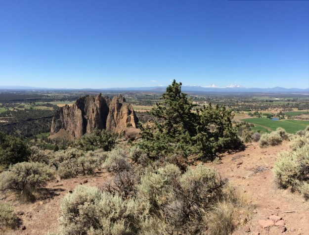
In the comics world this would be called my ‘splash page’, a picture related to but not exactly honest, done for effect. This is taken from the top of the popular destination Smith Rock State Park, on top of Misery ridge, the trails up and down of which have been the cause behind many an emergency run to the local hospital. Here we’re looking across irrigated pasture lands in the middle distance, that would be steppe if not for all of the added water and on to the Cascades along the horizon.
You cannot make someone like something. To many, a desert will always only look brown and dead, but for those attuned to them, deserts can be beautiful, awe inspiring, expansive, places of raw earth and geology, intimately tied to sky, filled with little jewel boxes, hidden just out of view and down at your feet…places of rock, delimited by the scarcity of water, with plants that not only tolerate its paucity, but require it, where the sun and wind seek it out. My wife and I grew up in the ‘Sagebrush Steppe’, the Oregon High Desert and on its edge where it meets the Ponderosa Pine Forest. I often spent hot summer days with my family water skiing on reservoirs in the dammed up canyons of the Deschutes and Crooked rivers, while she often found herself living out of places like Summer Lake and northern New Mexico for the summer. We both still feel the draw of these places, while others only hunger for more green and lush landscapes where the scale is shifted and plants cover the earth often with flowers that you can’t help be pulled to. As a horticulturist, I actually appreciate both.
Being transplants ourselves we often find ourselves on the road to and from Central Oregon and…driving passed many places we’re always saying we should stop at and check out. Well, today, we did that visiting Rimrock Springs in the Crooked River National Grasslands. This is ‘steppe’ country, where hot dry days can be punctuated with cool, even cold nights. It is exposed and expansive country with long views to the distant Cascades. Hwy 26, cuts a diagonal line from Portland, over the southern ‘hip’ of Mt. Hood, across Agency Plains, before plunging into the canyon of the Deschutes River and the reservation town of Warm Springs, then back up and out to the farm lands that surround Madras, farm land because here, through irrigation canals, siphoned off from much higher up on the Deschutes River, is the life giving water that makes growing crops possible. 26 continues south of Madras on its diagonal to Prineville gaining elevation onto what still remains as Sagebrush Steppe, unfarmable, without adequate water.
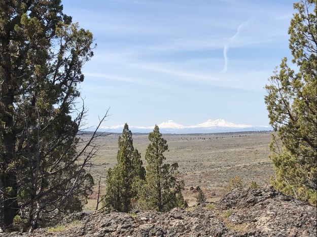
Taken from the high point on the Rimrock Springs trail looking across Sagebrush Steppe to the Three Sisters. The Grasslands are being actively managed to control the spreading Juniper, not just here at Rimrock, but throughout the Grasslands and elsewhere on most federally managed lands where it occursas wel.
This is Columbia Plateau country, the lands around here draining northerly into the Deschutes before it empties into the Columbia. Not too far out of Madras you cross the border into the Crooked River National Grasslands. There’s no river here. The Grasslands take there name from the river that skirts around it to the south, keeping a few volcanic structures like Smith Rock, Grey, Juniper and Haystack Buttes between the two. The watersheds, all drain northerly, bounded by the Cascades to their west, draining down across the much ‘younger’ lava flows that poured from the the Paulinas south of Bend, and the heaved up land that remains around the massive caldera, in whose collapsed center, the town of Prineville now sits and through which the Crooked River continues to carve its way. The soils of the Grasslands aren’t very deep and the precipitation they receive, is meager. Steppe country, around the world, is defined by its aridity, its large continental temperature swings and its paucity of trees. The steppe here is defined more by the shrubs that fill it with grasses serving as intermediaries and wildflowers nestled between, flowering, briefly and seasonally in rhythm with the rain and winter snow.
Rimrock Springs, as the name implies, includes much of the land that surrounds an ancient spring, water that the local geology has forced to the surface as it flows. It drains into Willow Creek to its east and north, which flows northwesterly in a narrow canyon cut through the basalt. In more recent years the land managers have constructed a broad low earthen dam below the springs, causing the few open water spaces to spread shallowly while increasing the wetlands that appear dominated by cat-tails from the viewing platforms and trail that are sited above them and to their south and west. This is valuable wildlife habitat and the managers chose to make this change for the benefit of the wildlife. This is deer and antelope country. The grasslands support them and all of the other wildlife that depend upon them. The spring provides a watering and rest stop for both area birds and those migrating, in fact, all told an informational sign states that the springs and wetland supports an estimated 500 different species from mammals and birds to reptiles, amphibians and insects….presumably fish too.


The Western Juniper, Juniperus occidentalis, is particularly well suited to the conditions here. There is disagreement about how the Grassland managers are selectively clearing/removing these trees. I’m no expert, but advocates claim that, due to our intervention, particularly our strict control of wild fires, the Juniper forest is spreading and dominating in ways that it did not before. My memory of this country is almost 60 years long and I agree that the country is less open and the trees more dominant…as to what we should do…I don’t know. Juniper trees, through their own growth, effect the immediate landscape. They are efficient harvesters of water in the desert and, by so being, ‘take’ water from other plants that aren’t so physically domineering. Studies have also shown how dominance of the Steppe by Juniper reduces its quality and suitability for various native passerine and songbirds. Dominance by Juniper also threatens the endangered Sage Grouse. The transition from healthy, diverse Sagebrush Steppe to Juniper accelerates as Junipers enter their mature phase. There are stories of this land, before our arrival and that of our cattle and sheep, of ‘seas’ of grass that are no where to be found today. It seems disingenuous to argue that we can’t ‘interfere’ now in this way when our very occupation of these landscapes is itself an interference. Better, it would seem to me, to instead work towards reducing our deleterious impacts on the land today and promote what we understand to be supportive of the ‘health’ of these places and I don’t claim to know what that may look like exactly, but I have a pretty good idea of the negative impacts our generally accepted and practiced activities are, which we should at least stop.


I imagine ‘steppe’ country, like this, is widely misunderstood by people who have not lived with it, whose understanding and values lean toward the lush, green landscapes, on which water is much more abundant. As harsh and dead as this land may appear to be to them…it isn’t. Well, harsh maybe, but dead, no. To appreciate this kind of place requires that we have eyes for it. That we know where and how to look. Driving along the highway at 60-70 mph, doesn’t give a person a sense for this place…it only reinforces ones sense of exposure, its scale, not the details. Even if you stop at the parking lot for Rimrock Springs and walk the paved trail out to the first viewpoint above the marsh, hoping to see some fauna, if you don’t slow down and pay attention in more detail to the ground around you, you are going to miss it. This is a diverse landscape, but you have to recognize it.
One of the information signs says the area receives about 12″ of precipitation a year. A few miles away in Redmond, the average is eight to ten with 24″ of snowfall, not all at one time and generally melting off between events. In Portland we range from 35″ to 50″ of precipitation annually, PDX, the airport, the official reporting station, is a generally drier 39″ or so. Both have a seasonal summer drought. With summer high temps about 4 degrees warmer in the Central Oregon steppe, the record highs are about the same. A real difference shows up in the summer lows with the steppe averaging 10-13 degrees cooler at night than Portland, 40 degree daily temperature swings are almost the norm. Winter minimums are considerably and consistently colder than in Portland and the Valley, the three winter months having record lows at or below -27ºF (I myself have experienced -25ºF in the early ’60’s in Redmond) with the daily average lows in the 20’s for six months. In the Portland area we range from zn7 in colder areas to zn 8 in terms of USDA growing zones, sometimes recording winters that are closer to zn9 with minimums never breaking the 25º mark! This part of Central Oregon is likely 6a or slightly colder. It is also important to note that all of the record low temperatures in summer, are below freezing. It can freeze there any night of the year. All of this has a very selective influence on what grows on the steppe. Many, if not most of the plants native to it, will suffer or fail if extraordinary measures aren’t taken to grow them on the wet side of the mountains.
")

")

")
")


")


The plants native here have often taken extreme measures in terms of their size, structure and growing cycle. Utilizing water efficiently and minimizing its loss are essential as is the capacity to withstand the minimum temperatures. Many annuals and herbaceous plants focus all of their growing energy within a narrow calendar when temperatures are moderate and water available. Herbaceous plants retreat from inhospitable conditions whether from cold or drought. Evergreens, minimize their leaf surface, often adding a thicker epidermis, heavier protective cuticle or ‘hairs’ to the surface that protect it from heat and the consequent losses through their stomate. All have competitive root systems that are able to get the water when they need it.
Western Juniper, Juniperus occidentalis, excels in these adaptations which is, increasingly, leading to its dominance of many steppe landscapes in Oregon. Its roots spread widely and are able to take advantage of what little water falls on the ground around them Their shed foliage and twigs are high in various oils which limit the growth of other plants under them, as does their dense habit. Their leaves are very small, awl shaped and tightly held or adpressed against the twig they are attached to reducing their surface area and any consequent water loss. Where Junipers grow well in close stands much of the diverse flora cannot grow, from grasses, to annuals, to herbaceous perennials and bulbs and with this is a reduction for its capacity to support many animal species.
Sagebrush, Artemisia tridentata, Antelope Bitterbrush, Purshia tridentata, Ribes cerrnum and the several Rabbitbrush species, all tend to have small leaves and provide valuable habitat for songbirds. Don’t be looking for any Manzanita out here, the combination of drought and winter cold restricts it to the slightly wetter areas that are associated with the mountains, often found with Ponderosa Pine that demand more water as well. While wetter woodland, savannah and prairie landscapes tend to have all of their soil covered in growth, often in dense, intermixed communities, the Steppe does not. Plants occur more singularly. Between the shrubs are scattered bunching grasses and between these are perennial and annual herbaceous plants often growing in tight, compact domes or cushions to reduce their surface area and water losses. This is particularly true of the evergreen species. Herbaceous plants tend to be shorter in stature as less water and energy is required for a smaller plant to reach flowering size and being able to continue on to setting mature seed. Other plants, still relatively small, may erupt quickly out of the ground with Spring in a flash of quick growth before going summer dormant. Then there are the bulbs with their stored energy which burst into flower and then display their modest foliage for a period replenishing the energy spent in flowering, storing it in their bulb, before again disappearing.
As you survey the ground you’ll see ‘bare’ soil in many areas between emerging plants in Spring. The soil is not flat and textureless. It is in coarse aggregates heaved up roughly in the regular freeze/thaw cycle and stitched together by various microbes, fungal growth, root exudates, mosses, algae and lichens creating a thin, fragile layer, known as a cryptogramic layer, a water accepting crust, that is vital to a healthy steppe. It protects the otherwise bare soil from erosion, adds Nitrogen and other nutrients and in its frost heaved state provides places for new seed to germinate, This crust is very fragile and can be easily destroyed by cattle grazing and our own foot steps. Once damaged it can take anywhere from 5 to 100 years to replace it as now unprotected areas erode, potentially shallowly burying adjoining healthy ‘crust’ which then, blocked from its light source cannot photosynthesize and maintain itself. Cyanobacteria in this layer literally have transformed this crust into a living plant system. Soils are never just ‘dirt’.
")


As you walk the trail at Rimrock Springs, keep this all in mind. There is a paved wheelchair accessible path leading to the first lower, viewpoint. The rest of the trail is very walkable, never too steep, but please stay on it. As you follow the loop clock-wise you get to the top of the basalt bluff with views to the west and the Cascades looking out across steppe. A week before we arrived a crew had come through doing Juniper removals, their stumps still evident and small piles scattered for either later removal or burning. As you drive elsewhere in Central Oregon, notably the stretch of Hwy 97 between Bend and Redmond, but in many other areas as well, you will see much denser stands of mature Juniper, that were you to walk amongst them, you would see how degraded these areas are by comparison. If you have time drive out east of Bend to the relatively new Wilderness Area known as the Badlands for another Steppe experience. The Steppe is being overtaken by Juniper and, yes, Juniper trees are ‘natural’, but through our presence here we have radically changed the conditions under which these landscapes existed for many hundreds, even thousands of years…..We do have a responsibility for them. If you do find yourself on this stretch of Hwy 26 do stop at Rimrock Springs in the Grasslands. It is a short hike of about a mile and a half. Do it soon to enjoy the bloom and be aware that summer can be quite hot and dry there and it will likely drive wet-siders away fairly quickly.
For those of you more interested in the Steppe regions of the world, in which ours is a part, check out: Steppes: The Plants and Ecology of the World’s Semi-arid Regions, by Michael Bone It is a very approachable coffee table size book with beautiful photos and interesting/helpful text that should not overwhelm.
There is also a classic well worth the reading that gives more of a ‘flavor’ for life on the ‘desert’ in its early settlement years, that I read years ago and still have on the shelf, The Oregon Desert, E.R. Jackman and Rueb Long. My copy, an early edition, was a gift to Julie’s grandfather in 1964, published that year by, The Caxton Printers in Caldwell Idaho.
