Monthly Archives: April 2024

The Flushing/Testing of Redmond’s New Municpal Well Into Dry Canyon’s Natural Preserve

This shows the effected portion of Dry Canyon Park from Antler, at the bottom, where the new municipal well is located, north to the Maple St. Bridge. The Fir connector trail shows up faintly cutting diagonally across the canyon from Fir Ave, 3 blocks north of John Tuck School. West Canyon Rim Park is labelled on the the left. The trail/dam cuts up, northeasterly from it, gray as it is asphalted, faintly in the pic. The water travelled 200 yds north of it, a bit short of halfway up to the Maple Bridge.

I’ve adopted Redmond’s Dry Canyon Park as a project, so I’ve gotten kind of possessive about things that threaten and effect it…but it is a City Park and cities often have competing demands and priorities. In this case the City is under considerable pressure to keep growing. People and businesses are still arriving here at a high rate and this puts demands on its public infrastructure, in this case its water supply. A city of its size also finds itself in need of more Park lands as people’s private space shrinks, population density increases and we all turn to the same limited landscapes for recreation. Compound this with the demand of wildlife and plants for relatively undisturbed landscapes on which they can simply live. Well, this is a case where two of these priorities have come into conflict, and as usual, the utilitarian demands have won out over those for the living natural world (There is no division of the City or local advocacy group, at this point, speaking up for the natural landscape and the life it supports). The utilitarian ‘needs’ of the community are simply a higher priority than those of the natural world. The State is responsible for our water resource and has control over adding new wells and how that is to be done. It is in at least part a health and safety issue. In this role they require that municipalities flush the wells and conduct a flow test to determine rate, drawdown and recovery. This was to be done by running it at full volume 24 hours a day for four days. At 3,500 gals./min. That’s 5 million gals per day. 20 million gals total. That water must go somewhere. It would have overwhelmed our wastewater treatment plant which is running at close to capacity already so it couldn’t be wasted down a manhole…so, it had to be wasted into the landscape of the Canyon itself.

The City contested this amount. This is almost double the amount used by by all residents on a typical winter day of 2.7 million gallons (In summer, due to landscape irrigation the daily amount jumps to 15.8 million gals.). This was all to be ‘wasted’ across the canyon floor. The City had concerns with damage to area infrastructure and paved paths. This requirement was cut in half and eventually to a single 12 hour period as the flooding/washing problem played out. The amount flushed was 2.5 million gals.

April 14, 2024

The filling ‘reservoir’ abutting the north path.

I was unaware of the details of this as I walked the stretch of path this afternoon  going north along the west side dirt path, from the trail connector between the main paved trail, extending from the Fir Ave. stairs. I was surprised at all of the surface erosion on and around the dirt path. In some places a foot or more of path had been scoured away, flushed out into the surrounding landscape, its Bitterbrush, Rabbitbrush and other low plants. This erosion continued north following the contours and the trail.
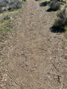
The northern extreme of the test run, where the flow slowed and settled all of the light organic debris.
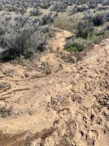
As the flow spreads and slows larger denser material settles out. Here sediment was deposited in the trail itself and on the ground where the water fanned out.

The flooding had continued a couple hundred yards to where the flow stopped depositing a layer of organic debris the water had carried along.

(I learned on the 17th that this was the result of a test to see what kind of damage might occur and to gauge how the water would spread across the site. This is why the crew was there on the 17th. The test was an attempt to determine the flow pattern so that they could minimize damage.) Continue reading

Creating a Survey of Redmond’s Dry Canyon Park Flora: getting the table set to create an effective maintenance and master plan

My wife and I are recently returned Central Oregonians, both having grown up here, me in Redmond. As a child my friends and I spent many hours playing and exploring in the central portion of Redmond’s Dry Canyon, many years before it was a Park. In those days it was all privately owned. Large sections of it had cycled through some years as pasture. Remnants of that era’s ditches are still evident in some areas. For several years plans were being prepared to turn a large portion of it into a golf course, which fortunately, was never built. The result is that as a ‘natural area’ the original plant community is severely degraded. The City’s master plan for the Park designates a large portion, the northern section, north of the dog park and disk golf area, north of Antler, as a natural area preserve.

I still feel a strong connection to the canyon and am beginning work that I hope will contribute to its health and diversity in the years ahead. I’m a retired horticulturist who spent the majority of my career caring for Park lands, previously with time spent maintaining private gardens and installing landscapes, mostly west of the Cascades. I began working for sever landscapers in Central Oregon. Continue reading

Dry Canyon Proposal: the need for change in maintenance, use and planning

[The following is a piece I wrote and sent to our local Parks staff, its advisory citizens committee, mayor and city manager…I got little back in response. I’ve developed a relationship with one of the city arborists and the park’s planner as well as have met several active neighbors interested in protecting Dry Canyon’s natural areas, several of whom have natural resources backgrounds with agencies. The City has no natural resource or botanical staff. There is no formalized friends group, nor is their an outreach and public education program that addresses these problems and the role of residents in their solution. Signage is minimal and inadequate. Their horticultural expertise would also seem quite limited. This is understandable as the City’s population has grown very rapidly in recent years. The need for such programs and an increase in expertise on staff will only increase as Redmond’s population continues to grow.]


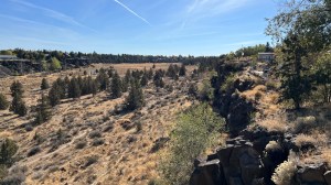
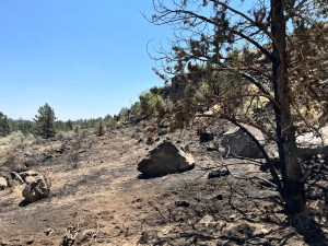
Redmond’s Dry Canyon looking south from the west rim on the Maple Street Bridge. The area in the immediate foreground burned this last summer.

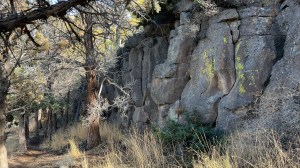
A typical view at the base of a section of relatively unbroken rim on the east side.

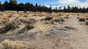
The canyon floor is variable, but as this pic shows, a solid layer of hardened lava underlies what soil is here, either blown in or washed in, a limiting factor of what can grow here. Rabbitbrush is a common and ubiquitous native pioneer.

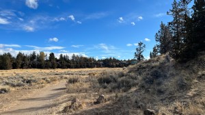
Match of the canyon floor is recovering from pasture use. These areas have relatively deep soils and are still transitioning with many weedy mustards, annual grasses like Cheat and planted grasses like Crested Wheat and Annual Barley. Native Bluebunch Wheat is scattered as are other natives. Gray Rabbitbrush, a native seral species has moved into much of it, but the weeds are dominant. Sagebrush and Bitterbrush are more at the edges and lower rim areas.

This section of bottomland, former pasture, probably burned not that long ago, has quite a colony of Rabbitbrush coming along, all it would appear of even age, suggesting a fire. Rabbitbrush are early colonizers and ‘prepare’ the way for natives to follow. This is just north of the Maple Bridge.

This area, maybe 5 acres, burned in July. It will be interesting to see what comes back and what the City may plant??? Fire kills Sagebrush and Juniper, while it seems to favor Cheatgrass. So far, April ’24, nothing has been replanted. The window for seeding is closed. Rabbitbrush can survive a burn. This site is unfenced, with very fragile soils and we’ve already observed new bike trails in it.

My wife and I are both recent returnees to Central Oregon having both grown up here. We are also frequent walkers in Dry Canyon, a place I spent many hours in playing and exploring as a kid in the 60’s. Redmond has changed a lot over the intervening years…change that continues apace as it grows. I’m not going to whine about the ‘good old days’ and things lost. Much of the change I welcome or at least accept (We did move back!), but population growth, in addition to bringing along economic vitality and stability, new and enriching opportunities and a more diverse community, increases the ‘pressures’ on the naturally limited assets that largely define the place and attract residents. I’m speaking here of the natural landscape, its features and the opportunities which it affords us for recreation and quiet enjoyment. Realtors were once fond of saying that no one is making new land, as a prompt for buying…it is a fixed and limited quantity. This limitation has profound implications for a growing population. We have far more people today ‘enjoying’ a limited, and increasingly over utilized landscape. Continue reading