
It’s the edges, the margins, that always contain the most diversity. Large expanses of unbroken landscape take a portion of their character from their scale, a vastness, that the uninterested can often view as monotonous. Seemingly endless expanses of ocean, desert, prairies even forests, can lull some into indifference, a kind of blindness, in which they lose interest and fail to see the intricacy and richness of that which surrounds them….By overlapping two different landscapes places can take on a complexity that neither has alone…and may even arouse many of those inured to the natural world surrounding them. Two different landscapes sharing a common edge can form ecotones, where each landscape contributes species in patterns not found across the vastness of each alone. Cut a river through an arid landscape and it becomes altogether different often with stark changes within a few feet. Such is the arid canyon landscape of the Deschutes River immediately north of Bend, OR.


")
")
")
")
Bend sits on the edge of the Ponderosa Pine Forest and the Sagebrush Steppe in an area where the Western Juniper has been allowed to become more dominant. The Deschutes River flows down out of the eastern central Cascades turning north across the plateau country on its journey to the Columbia River, leaving the Fir then Pine forests behind on its way. It is this juxtapositioning of geography and botany that provides the Bend area with so much of its appeal. This is where the Riley Ranch Nature Reserve (RRNR) is located. (Interestingly, Riley, the homesteader here, once held grazing leases in the Deschutes headwaters country which later became flooded when Crane Prairie Reservoir was created, ironically, negating his summer grazing lease, as the land was submerged to help store water for irrigation downstream to aid those with pasture lands and farming in Central Oregon, undercutting his ability to continue ranching.)
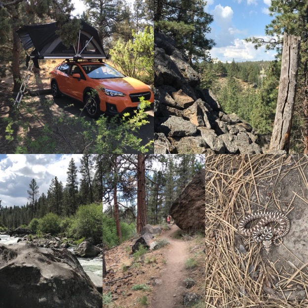
Julie and I spent a couple nights in late May at Tumalo State Park, about a mile and a half downstream from RRNR. A well designed, built and maintained trail joins the two parks together following the river near the toe along the sloping eastern side of the canyon, both rims rising well above, the trail often traversing or crossing around tumbles, or falls, of fractured basalt that broke away from the rim above. Along one such stretch of 200′ or so the massive basalt fall comes right to the river and an engineered bridge/path floats, supported above it. The trail has a mostly uniform grade. You do need to pay attention to your footing, remember all of this rock, which is stable, but can cause you to stumble if you are to casual in places. There is really only one exception to this and that is along Robin’s Run, within the RRNR, along the steep pitch that climbs out of the canyon on an irregular series of natural stone steps and twisting ramps…not a built stairway! The only other steep portion is the very short pitch at the trailhead, downstream, near Tumalo State Park.

")
")
")
")


The river was here well before the more recent lava flows that filled its former canyon forcing the river to change its course and carve out a ‘new’ canyon adjacent to it. It is impossible to ignore the geology of this country. It is upfront and in your face everywhere! There is informative signage pointing out the basics of the history of the landform and rock of this area. There are several accessible books explaining the local and regional geology of this region that will inform your own understanding of what you are looking out and how it came about.


The signage at the trailheads, junctions and along the route is superior, clear and well done. Of note are the admonishments that the trails are not open to bicycles! two of which we met along the relatively narrow trail, the riders feigning ignorance who then tried to downplay it jokingly when we confronted them…you know the type. It is also good to keep in mind that dogs are allowed only on the connector river trail, but not anywhere in the RRNR.
We began our walk from Tumalo State Park. There is a trail that continues passed the lawn at the south end joining the trail from the parking lot. This goes a couple of hundred yards before meeting a private paved driveway that quickly delivers you to the trailhead right next to a private bridge that crosses the river to a home across the way.
")
")

")
")
")
The canyon trail is within the Sagebrush/Ponderosa ecotone, Juniper is intermixed with Ponderosa Pine and open swathes of Sagebrush and meadow all within the steep and sloping canyon walls of tumbled basalt. Here are species of both landscapes. The most notable exception is the area Manzanita, Arctostaphylos patula, which is common south and west of Bend, but not here. There is lots of Bitterbrush, Purshia tridentata, and Wax Currant, Ribes cereum, above the trail mixed with the Artemsia and much lesser amounts the Ceanothus velutinus, Snow Brush and the drought dwarfed Western Serviceberry, Amelanchier alnifolia. This spills down towards the river where it loses out to the native shrubby Alder, likely Alnus incana, the smaller shrubby form, dense thickets of Spiraea douglasii, Cornus stolonifera, the Redtwig Dogwood and Prunus virginiana, or Western Chokecherry where it grows as a shrubby thicket along the river bank, which were in full bloom during our visit. Here too is at least one shrubby Salix species with a scattering of Rose as well. Down at the water’s edge we saw what I think is Western Blue Flag Iris, Iris misouriensis, budded, but not yet in bloom, with its glaucous, bluish foliage. Sadly, there were also scattered clumps of Iris pseudoacorus, the invasive, with its bright yellow flowers and shiny, medium green leaves, especially closer to and in Tumalo State Park. They’ve attempted to control/limit access directly to the water, the density of the shrubs helps greatly with this, but there is plenty of evidence of hikers taking random routes down slope, disturbing the soil kicking smaller rock down as well. The disturbance has lead to a significantly higher proportion of weeds like the invasive Cheat Grass. Upslope, above the trail, is clearly dominated by the native Fescues and other grasses.
")
")


As you walk the trail there is considerable variability in the ground layer with some patches almost of solid Mahonia repens, others of Sagebrush, while others still were predominantly grasses. Wildflowers were evident everywhere. Everyone recognizes Yarrow, Achillea millefolium. I found myself scanning for my favorites and was a little surprised at the dearth of Penstemon. I noted only 3 Castaleja maybe Applegate’s Indian Paint Brush as well, while there was a lot of Lupine, including Lupinus lepidus (?) and probably a few Milk Vetch, Astragalas, though none were blooming. My grasp of desert and arid land wildflower species is a little weak, but I did note several different Lomatium and Eriogonum species along the path. Balsamorhiza careyana, though I wouldn’t stake my life on this ID, occurred throughout the area in single and multiple clumps. Scattered throughout the canyon in slight shade Western Wallflower, Ersyimum capitatum, was here and there as was at least one species of Phacelia. There were many other herbaceous species, not yet blooming, that I would not even hazard a guess at.
")
")
")
")

")
")
")
")
")
")
")
")
Down in the canyon, within the RRNR itself, I also spotted the little native aster, Townsendia florifer, as well as a scattering of Larkspur, Nothocalais troximoides, the False Desert Dandelion, Redstem Spring Beauty, or Claytonia rubra and, the find of the day, a juvenile Rattlesnake!!! sans rattles, holding its ground threateningly on the edge of the river loop. Here, the canyon bottom is broader and not only was there space to graze cattle down here, but it was also the site of 3 log structures, two of the them cabins, now all well on their way to rotting having collapsed many years ago. The old pastures here, like above, with irrigation absent, are being reclaimed from pasture grasses and the Eurasian weeds that had taken hold. For me, this must have been a truly idyllic place to live, though as bottom lands the cold would have settled down here posing a threat to veggie gardens compounding this country’s already brief summer growing period.
")
")
")
")
")
")
")
")
")
Climb the trail out of the canyon along Robin’s Run, a steep pitch that probably limits the less than sure footed, to the flatland atop the rim and near the parking area of the Reserve and you’ll find yourself firmly in the Juniper/Sagebrush Steppe with the expected change/reduction of species. Much of this is old pasture undergoing restoration with its rocky perimeter and occasional rises populated with the familiar steppe plants. Two loop trail traverse most of this and they are broad and smooth topped with 1/4 minus gravel providing a surface suitable to families with young children and strollers. On our visit some areas had been disked with raw exposed soil. I’m not sure what their immediate plans are for it in terms of planting or if it was just a tactic to eliminate a particularly pernicious weed. To the outside of this path it is all too common to find the invasive Cheatgrass already well along on its way to producing seed!

")
")
")


The upland portion of the reserve is broad and open, covering about 150 acres. Most of the old pasture area is devoid of trees including neither Pine nor Juniper. When we visited it was around 70º. Without shade, this area will be hot on warmer days, so choose your visiting times accordingly. Along the top of the rim are two well sited and built viewpoints. One gives a view upstream, toward the river where it has carved its path around the ‘point’ below Awbery Butte. The second is a platform, further north, that projects somewhat over the rim’s edge, great for observing birds that work the canyon below. Another spur trail winds quickly to a low rocky bluff within the ‘meadow’ to give a little longer view, while closer to the main parking lot is another formal viewing area that provides a panoramic view of the nearest Cascade peaks and foothills.
For most people the diversity of species in our arid landscapes will probably come as a bit of a surprise. Too many people only see ‘dead’ and ‘brown’. Pick up a manual that focuses on these plants. Look closely as you walk the trail and observe. Train your eyes. Take your camera along and reference the Wildflower Search website, as I did here, which will give species lists for the specific area including the likelihood of finding a particular plant on that site at the time of year you are looking. It is an amazingly helpful and exhaustive site, produced by Steven Sullivan, the brother of NW hiking book author, William Sullivan, with lots of references and links to photos and descriptions, created and found elsewhere on the net.
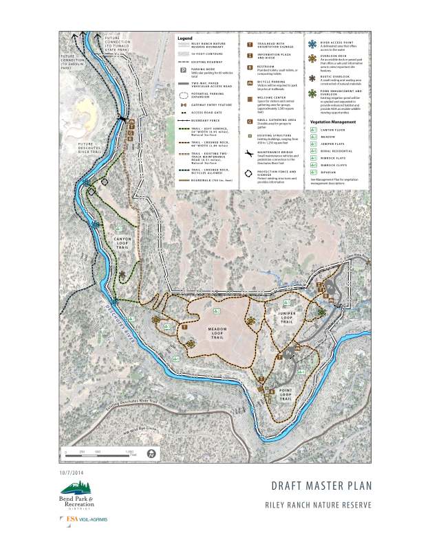
The Master Plan for Riley Ranch Nature Reserve, Bend Metro Parks and Recreation, Mar, 2017
The master plan pictured above, includes the future expansion and improvements to the Reserve. I presume plans are underway to complete the entire project, but this doesn’t always happen or can take many years due to funding, land acquisition or easement issues. The Point Loop portion is not open. As everywhere property owners aren’t always supportive of projects that bring the public on or next to their own little bits of paradise. The trail to Tumalo State Park is open. The expansion of the connecting trail system, making it possible to walk the river to town or cross the river and hike all of the way to Shevlin Park west of Bend, along Tumalo Creek, have long been anticipated and will someday be wonderful assets for area residents and visitors alike.
Overall the RRNR is a very nice addition to the Bend Metro Park and Rec’s portfolio of parks. It is unique in its system as a nature reserve and like all such efforts sorely needed as the urban area continues to sprawl out across the land forever transforming this unique place. One can only hope that the area adopts a more compact pattern of growth to protect Central Oregon because there is no sign of growth slowing. Sadly, this seems a little doubtful as there is a strong anti-urban sentiment common amongst residents, the newly arrived all wanting their own piece of paradise. Much is being lost as should be expected.
On the day following our hike we drove to Bend along OB Riley Road, the same Riley of the Ranch, to Glen Vista which takes you west to the main parking lot at the Reserve. Across the road from this street preparations for a large development were underway. The site was dominated by the coarse and irregular surface lava flows that solidified here thousands of years ago. Early construction/grading was underway with the sounds of heavy equipment and jackhammering which was probably preceded by extensive blasting, homogenizing the entire site into a typical and uniform subdivision. Hopefully, the Reserve will help awaken residents and developers of Bend, Redmond, Sisters and other area communities, to the natural beauty, literally at their feet and spur them on to consider what they are doing to this place. For now the land’s main value lies in our ability to convert it into housing and profit. At least some of us, who still think of this region as ‘home’, are pained by the rate and patten of growth that continues and the consequent loss of the unique natural character of so much that is essential to the quality of life that has attracted many thousands here since the discovery and boom of this place as a mecca for outdoor recreation.
More Information and Things to Do!
Here’s a link to a list of native plants along the Deschutes River around Steelhead Falls further downstream in Crooked River Ranch. The list area is a little more isolated being further out in the sagebrush steppe country so it will vary slightly from those found at RRNR. Check out their, Guide to Common Native Plants of the Deschutes Canyon Area, by Marilynne Keyser published by the Friends and Neighbors of the Deschutes River Canyon. This is an active group who advocate, provide education and lead guided hikes as well as do conservation work centered around the Steelhead Falls area of the Deschutes River.
Participate with and become a member of the Oregon Natural Desert Association, ONDA, based in Bend, another advocacy and education group who are busy doing replanting projects, invasives control, leading guided hikes and providing social and education events to members and the public.
The Deschutes Land Trust’s mission is to work cooperatively with landowners to conserve land for wildlife, scenic views and local communities.
The Oregon Nature Conservancy, a long established organization, has taken on the intermountain west’s vast sagebrush steppe country, among others, working on the ground to restore and protect this neglected and abused landscape.
Take your family to the Oregon High Desert Museum south of Bend on Hwy 97 as an introduction to the values and history of this desert country.
