
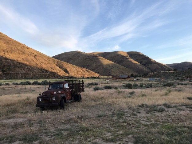
Cottonwood Canyon State Park, near the campground, looking upstream toward the old Murtha barn and common buildings, the evening sun climbing the worn canyon sides. The Park retained some of the old ranch equipment.
Massive lava flows pushed around the lower John Day and Deschutes rivers over the course of several million years leaving them to find and carve new routes, often next to the very ‘plugs’ that filled their former canyons! Today, deep below the layers of hardened basalt that form the palisades and ramparts projecting out in tiers from the smooth full curves that rise above us, we look through 15 million years of accumulated history. The fine grained basalt shatters and fractures in line with their mineral structure under the forces of water, weather and gravity. Sagebrush and grasses dominate revealing an oddly ‘netted’ pattern across the sloping canyon hillsides, lit by the often harsh sunlight, illuminating some kind of subsurface movement of the thin soils that soften the slopes. The ‘net’ looks as if it had been draped across the land then stretched sideways catching and snagging on what lies beneath in a never the same, but consistent repeating pattern. It shows best when the angle of the sun comes across the pattern, not when it hits it head on or when clouds make it too diffuse. Coarse falls of shattered basalt spill down to the canyon’s bottom always seeking their angle of repose. The sagebrush steppe plant communities cover the surface and in their richness and vigor speak to the soils beneath. Along seeps and drainages cutting verticallly down the canyon’s face, spring lasts weeks longer, and species crowd in that you won’t see other than near the river. The surface botanical palette in this way reveals what lies beneath…if one knows what to look for. Cottonwood Canyon State Park is a great place to observe this.
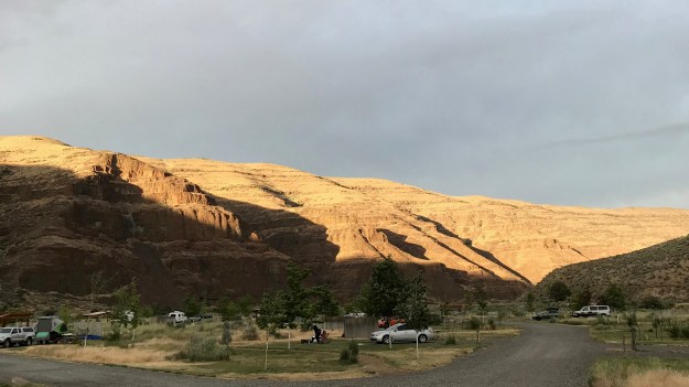
The namesake, Cottonwood Canyon, leads east, carrying Hwy 206 away from the river. This is a new park and to our eye, idylic. With some facilities still under construction and relatively remote, the Park lies a few miles east out of the small town of Wasco, lying just beyond the vast wheat fields and wind generators keeping time by the hundreds. The next public access north is at the Columbia River, 25 miles away, some 38 ‘river’ miles. Clarno, 40 miles south, is the next nearest public access, upstream, where rafters, kayakers, even those on SUP’s can put in. When we visited at the end of May the river was still running high and ‘brown’. There were vehicles parked across the river at J.S. Burres State Park, the long time Cottonwood take out point. Maybe a dozen camp sites were occupied where shade trees and a lawn have been planted to ameliorate the effects of summer’s heat. Short ‘fences’, wind breaks, have been installed at each site next to the picnic tables to provide shelter from the very common wind. A few have had shade frames erected above the tables, they’re the first to go. (The previous weekend, Memorial Day, they were ‘hammered’, even their overflow space maxed out.) The expanse of lawn around the old Murtha barn, plumbed restrooms, covered group picnic shelter and information house were almost completely absent visitors. In this area only the sound of the old windmill, spinning, but no longer used to pump water, and the occasional single vehicle crossing the bridge, are heard. Other than the sounds of construction, a hundred yards off, midway between the campground and the barn, where they are building showers and an education facility, one end including a ‘corral’ anchored by Juniper posts, it was quiet. The adjacent area is being prepared for additional camp spots, but are not yet ready. Throughout the Park the sounds of birds dominate the river as it moves quickly and smoothly by.
We arrived late in the afternoon, just after the 4:00 check in, secured our space, its first come, first served, there are no RV hookups, and were surprised to find that the Park supplied single speed bikes to visitors to negotiate the grounds which stretch out along the bottom lands. Nice! Did I mention that the wind was blowing? It was! Consistently over 20mph and gusting higher. We chose not to put up the tent right away and instead headed south, upstream of the 206 bridge, along the Hard Stone Trail for a mile and a half or so making the turn below the cliffs you can see from the main park taking us to the next bend facing the river and cliffs to the other side where a stone bench has been placed. A beautiful spot. The trail is of an easy grade with a good surface.
Invasive Plants in Parks and Public Lands
As an old Parkie myself, and a horticulturist, there is something I have to discuss here. This Park is 8,000+ acres! 8,000+! That is over 12 sq.mi. Through this the John Day winds with 16 miles of riverbank bound with just over 300 acres of bottom land that once served as cattle pasture, now degraded and infested by many Eurasian weeds and suffering from the onslaught of way too many invasives! The rest are uplands, much of it very steep! Here you’ll commonly see, what the two Rangers (that’s right there are only two staff to see to the management of the landscape assisted by park hosts in the developed portion only with the guests), call ‘old growth’ Scotch Thistle which can stand well over my head.


There is at least one Knapweed, the Russian species, Centaurea repens, just coming into bloom along the river trails here, often in large sweeps filling in between plants of Big Sagebrush, Artemisia tridentata, taking valuable space and resources away from the desirable and higher value natives of the Sagebrush Steppe community, including Gray and Green Rabbitbrush. The Knapweeds occupies space that should be filled by wildflowers, native bulbs and grasses, as it can grow in dense smothering swaths. The John Day Country is also plagued by other Centaurea species, including the other shrubby perennials, Diffuse, C. diffusa, and Spotted Knapweed, C. maculosa and the annual, Yellow Star Thistle, C. solstitials. We saw the Russian mostly on the stream side of the trail, on the fills and cuts, but could see it growing out on the flats as well as creeping upslope from the trail. In bloom these can be quite striking. We were visiting at the very front end of their bloom season. Looking out across sweeps of green I could discern its particular texture. In bloom these are hard to miss. They are fully capable of invading undisturbed dry steppe country and decimating local bunch grass and wildflower populations in the process, flat out reveling on disturbed sites. It spreads from both seed and root, an ability possessed by many invasives. People often don’t see these as ‘bad’ plants out here as they are neat in habit and provide ‘color’ to what many consider a ‘drab’ palette. They can also associate these favorably with the common Cornflower or Bachelor’s Button, Centaurea cyanus, an old fashioned cottage garden plant and roadside weed following us from Europe. Chicory, Cichorium intybus, another Eurasian weed, once used to brew a coffee substitute, is similarly viewed by the public. Chicory is common here and elsewhere on the dry side of the state as it is across many North American disturbed landscapes. As a semi-arid site, visitors need to understand that invasive plants like these, though they look innocuous, or even ‘pretty’, are ‘ecosystem disruptors’, meaning that they seriously upset the balance of the living landscape here with repercussions that we can only guess at to both the plant community and wildlife. Our unwillingness to prioritize the control of such plants across vast stretches of private and public lands does not bode well for the long term.


I have to mention the Bromes here too, they are a problem across much ot the Intermountain West and here is no exception. These are related to the False Brome, Brachypodium sylvaticum, that has the lower Willamette Valley as its epicenter, though it is now found in the Portland area to the north and as far away as San Francisco. The plant list compiled by the National Park Service for the John Day Fossil Beds National Monument, through which a portion of the John Day runs, is helpful for the conservationist and trail side botanizer. It lists exotics as well as natives. Among the exotics are five different species of Bromus that infest this country, Bromus commatatus, B. hordeaceus, B. rubens, B. tectorum (the one we all hear about, the all too common Cheatgrass) and B. brizaeformis. I’m sure several, if not all of these are here at Cottonwood Canyon. All of these have the long characteristic ‘awns’ that get caught in socks, boots and other clothing as well as in the ears of pets and livestock. It makes poor forage as it matures and they seem well adapted to growing conditions here, especially given the grazing history and the disruptions still suffered by native landscapes. It has become increasingly difficult to find any landscapes one could truly say are ‘undisturbed’. Cheatgrass, in particular, is a prolific seeder, producing seed very early in the summer. and it thrives on fire steppe landscapes typically cyclically experience, adding its quickly fading/maturing top growth as fuel. All of the Bromes ‘take’ space, water and nutrients from the much more desirable natives.
The inaccurately named Himalayan Blackberry, Rubus armeniacus formerly known as R. discolor or R. procerus, seemed controllable here when we walked the 4+ miles of the Pinnicles trail downstream of the campground appearing in only one spot that I found, though on the next day, walking a section of the Lost Corral trail on the opposite, more shaded side, the Blackberry covered extensive sections of steep riverbank and could easily be seen out in the bottoms and the ‘island’ and bar where the canyon widens along the eastern reach a mile and a half down from the 206 bridge. It’s more than a bit disheartening to see…and a huge task for the two rangers to be responsible for.
")

")
The list of weeds and invasives goes on. I was startled to see Clematis romping through, in and over many plants, in the river bottom lands, including Big Sagebrush and native Mock Orange, in an all too familiar manner. In the Willamette Valley we face the scourge of Clematis vitalba which grows into heavy woody vined mats pulling down and shading out native and exotic trees and shrubs alike. In sun, it can even bury ‘English’ Ivy, now recognized as another species, Hedera hibernica. This dryside Clematis looks very much like C. vitalba, but no, it isn’t. Here in Oregon’s arid eastern portion can be found, Clematis ligusticifolia…and here is another reason for us to learn the nuanced differences between species so that we don’t ‘paint’ them all with same broad brush and take incorrect action. C. ligusticifolia does not have the rampant vigor of its Valley neighbor growing to a maybe a third the size. It has ‘unisexual’ flowers instead of bisexual or perfect flowers. I didn’t know this until I got home and checked a technical description of the flowers of the two different species. At the time though, I couldn’t shake the slightly queezy feeling that the sight of this Clematis at Cottonwood gave me…not even the Butterflies we observed visiting their flowers everywhere could allay this. The Willamette Valley invasive, still currently spreading and taking over an ever increasing portion of west/wet/side landscapes, has not yet found its way here. The Columbia River Gorge provides it an avenue to find its way, transitioning between the two. Frightening to me would be the case where the two species meet in the ‘middle’ and hybridize, possibly producing progeny that share the eastside species hardiness and drought tolerance with the vigor of the other!
As botanists do, when supported by meager budgets, they study native plant communities and the impact on them by invasive exotic plants and other human caused impacts. Generally, as new exotic species move in they quite ‘naturally’ follow various traffic corridors like rivers, roads, railroads and trails spreading out from these into adjacent and nearby sites. These literally provide an avenue for their movement, and humans, through our activities, facilitate and accelerate this….Plants don’t spontaneously generate. These exotics often find disturbed condition along these routes that are at the additional disadvantage of having compromised landscapes, including bare, or poorly covered, possibly depleted, soils that these exotics are very well suited to. They arrive as seed, whole plants or as bits and pieces of plant material capable of establishing and reproducing. When dependent solely on the movement of water, wind and wildlife, plants are very slow movers. When augmented by human commerce, development, disturbance and these days, recreation, they can move several or thousands of miles in a day. This is why these corridors support the highest concentrations of weedy and invasive species and why we often see it decrease with distance from them. New populations of them can skip over land from these corridors, beginning ‘new’ populations in a manner similar to a leading edge of a fire with embers carried on the wind, creating spot fires. In this case ‘we’ are often the wind.
Brief Note on Butterflies and Birds
I am not a butterfly guy, but we both agreed that we’d seen at least 6 different species over the two days, plus the ubiquitous Cabbage White flitting between the many Mustard family bloomers, including perhaps the Great Spangled Fritillary, Painted Lady Butterfly (?), Spring Azure Butterfly, White Admiral Butterfly, Mourning Cloak Butterfly, the Melissa Blue (?) a visitor of Locoweed and Milk Vetch and a few Swallowtails!!! Forgive me some of my wild guesses here as a novice! The point is that butterflies were plentiful here during our visit and living in Portland as we do, where they are all too rare due to the habitat destruction that accompanies our pattern of urbanization, it was truly fun to see them in such numbers. There was a little moth, around a half inch long that would land on me repeatedly and another that rode along on the end of my phone for awhile, maybe a half inch in length. As we walked the trails the butterflies would often fly and land a few feet ahead of us or just keep flitting around like dolphins before a bow wave.
There were way more birds than we could begin to identify with probably thousands of Cliff Swallows, their mud nests clinging to the basalt above us, some easily visible just off the trail. Redwing Blackbirds were everywhere along the river their trilling calls almost constant at times. Magpies and Ravens were evident as were smaller hawks. We spied a colorful Bullock’s Oriole in flight that landed in a nearby tree top as well as one of the Sialia species, either the Western or Mountain Bluebird, near the river. We heard the shrill cry of hawks high overhead when we hiked below the cliffs along the Hard Stone Trail.
The Hard Stone Trail

The river was still running high and fast at the end of May here inundating a gravel bar.
Our first hike was an evening one, about a mile and a half, out and the return. All of the formal hikes here are out and backs with the trails located in the canyon bottom. Because of this all have easy grades and the surfaces provide easy walking though I would say you should have sturdy, supportive hiking shoes or boots because the base rock in places can cause you to roll an ankle and in others it can be loose. These are open to bicycles for those not having the time or interest to walk them. They aren’t ‘technical’ and won’t provide any adrenaline rushes for the ‘hardcore’ single tracker. (Horses are limited to the Lost Corral trail.) No trails have been created that explore the bluffs and canyon rims up above though the Lost Corral has an optional loop at its end that takes you higher onto the framing canyon sides and there is a ‘trail’, the ‘Gooseneck Ridge Trail‘, for the more intrepid hiker with good ‘route finder skills’. I look forward to more options being added.

Most of the trail is dominated by Big Sagebrush with many stretches, like this one, dotted randomly with Netleaf Hackberry.
The Stone Trail follows the river upstream from the highway’s bridge crossing through some stands of Big Sagebrush above my head. In the trail sections closer to the river bottom it often ranged from 6’ to as tall as 12’! Along those sections carved out of cliff faces, others on slightly higer elevation with thinner soils and some of the raised ‘flats’ they were generally no higher than 3’ or 4’ thinning out and making more room for the expected shrubby neighbors, grasses and wildflowers. The Scotch Thistle was scattered in patches, mostly in the first mile of this trail as was the Clematis which would romp through sections here and there closer to the river.
")
")
")
Throughout this section the same shrubby tree would confound me until I got home to figure out what it was. It occurs along much of the Lost Corral and Pinnacles Trail as well. Probably a bit drought stunted, these grow with relatively short internodes creating a rather stiffly growing plant somewhat resistant to the wind. Most contain significant amounts of dead branches and their smooth margined, medium green, almost leathery feeling leaves, which grow into the relatively dark ‘blobs’ that stand out amongst the predominantly ‘silvery’ and tawny colored neighbors. The trees seem to suffer from some kind of small gall often resulting in a deformation or twisting of the remaining healthy leaf tissue. These appeared to belong to the Rose Family on first glance, because of older dried up and retained fruits still retaining the sepals from the the blossom end of the flower causing me to suspect that it is some kind of crabapple or the native Pyrus, now known as Malus fusca…but no, it wasn’t. Nor was it the native Hawthorn. Instead I think this was Netleaf Hackberry, Celtis reticulata, a valuable wildlife tree in this country which was once in the Elm family, now included in the expanded Cannabaceae, within the Rose order, thanks to the ongoing revising of the botanists working in the Angiosperm Phylogeny Group.


Another dominant player along the river is a slivery, narrow leafed Willow, just passed blooming. Here along the banks and on gravel bars these often crowd each other spreading and suckering from their roots forming dense thickets. The Willows are a confusing lot. The silvery hairs on this one blends in well with all of the tomentose and silver that dominates the other shrub species here. My best guess is Salix exigua, the silver, narrow-leafed Willow, which is supposed to occur along the John Day and is common across much of North America.
The lowest lands here were probably the most intensely used pasture lands on the old Murtha Ranch which was a long time occupier of this area since the arrival of European-Americans. Such disturbed lands gave the Eurasian weeds we brought with us the perfect environment to incubate, increase in numbers and then to use as centers from which to spread to surrounding lands. There are a good variety of wildflowers to see here in spite of the invasives, though it’s difficult to say how much has been lost.


")
")
")


Being a Penstemon guy I was happy to see Penstemon richardsonii, though it was fairly limited along the trails. I saw it most commonly along this, the Stone Trail, generally on falls of the shattered basalt or sometimes in its fractured face. Along this section of canyon these areas were east facing recieving some relief from the afternoon heat by the alignment of the canyon walls, though I didn’t see any on the north facing walls where the river turned abruptly eastward further downstream, though this isn’t an exhaustive survey. This is a fine plant with its evergreen leaf margins uniquely cut, ‘dentate’ with a regular coarse serration. This is one of the ‘subshrub’ species of Penstemon that generally retain their above ground structure. Their reddish purple flowers were still evident, though slightly passed their prime. In the same ‘screes’ could be found Wild Buckwheats, or Eriogonums, which along with the several species of Lomatium found in the area are nearly as iconic and identifiable with eastern Oregon as are Western Juniper and the several Sagebrush species that dominate the same named steppe country here. There was one Eriogonum right next to the Penstemon in the large scree I first spotted it in. Interestingly there is almost no Western Juniper in the Park that we saw other than a few very widely scattered individuals.


The trail turns to follow along a westerly flowing reach of the river, below a face of broken cliffs that step their way back up out of the canyon. There is one twist in the river after the other as it flows along its 240 mile undammed course, the river always scouring away on the outside of such abrupt bends, giving cover and some relief to the plant commuinity here along the northerly facing portions like here. Several other shrubs are featured more commonly in this stretch, among them our native Mock Orange, Philadelpus lewisii, a few of these would have made gorgeous specimen in any garden. All were in full fragrant bloom. (Because of a few recent conversations these cliffs give the imagination places for Cougar to perch and watch from above!)

")
")


")
")

")
The river slides through another turn to the south leaving an expanse of broad flat bottom land built up from sediments deposited by previous floods or blown in from high above on the ‘inside’ of the bend. Here the land is mostly flat and is high enough above the river to be starkly dry. There is a mix of steppe shrub species broken with grasses and wildflowers including several species of Lomatium (not to be confused by the garden geeks among us with Lomatia a southern hemisphere genus of plants in the Proteaceae, with very different habits and requirements) and Orobanche fasciculata, Clustered Broomrape, a beautiful, almost golden eruption out of the soil where they are attached to their host plant’s roots. In this part of Oregon they commonly occur near Composites, Sagebrush, Oregon Sunshine and Eriogonum’s, all of which are found in abundance here.
As we approached our turn around point, dusk was falling and the light was retreating up the canyon’s slopes, a coyote loped across the trail ahead of us disppearing into the Sagebrush. Julie saw another the following day quickly retreating away up slope in mid-afternoon. I’ve gotten strangely used to the almost fearless coyotes that live in and around Portland behaving brazenly. One stopped me in the road at Washington Park, a few years back, ten feet in front of my truck, then casually dismissed me before loping off after I got out. These over here fear getting shot by ranchers and locals many of whom, are undoubtedly like many I knew when I was much younger, who often carried a 222, a varmint rifle, for just that opportunity! We never used to see them closer than 100 yards or more and always after they had seen us.


Near the bisector of this bend is a nice stone bench, a memorial for the fisherman and advocate, Norb Wellman, a charter director of the Western Rivers Conservancy, the organization that originally bought the Murtha Ranch and held it until the state was in a position to purchase it from them. Wellman died in 2015, so this is a fitting memorial. It’s a beautiful spot just back from the river’s edge, with the uniform rows of prismatic basalt forming the base of the cliffs on the opposite riverbank. The State Parklands actually follow the river through and into this end of the 70 miles of Wild and Scenic River including 3 Wilderness Study Areas, which this particular area is a part of. Visit the Oregon Natural Desert Association’s, page on this. I’m not sure how much of that is acessible by this and other trails. Something to explore!


We turned back, took a few more pictures, noticed a few other plants and spooked a large Mule Deer back up the slope which had probably been coming down for water. He skittered easily up the broken basalt, stopping occasionally to watch us, at least until we were out of view.
 By the time we got back to camp the sun illuminated only the top most western facing slopes of the canyon. The wind had subsided…mostly, and we put up our tent.
The Pinnacles Trail

Leaving the campground along the Pinnacles Trail
The next day was clearer, warmer and less windy so we decided to do Pinnacles Trail. Like the Stone and Corral Trails it served for many years as a road on the old Murtha Ranch. It follows the river 4.3 miles downstream before ending requiring visitiors to double back. In addition to rattlesnakes, signs warn hikers to carry 20 oz of water for each person for each hour on the trail…we didn’t becasue the high temp was only expected to just break into the low 70’s. You should take this recommendation seriously as the canyon can quickly become an oven on warmer days with all of the reflective surfaces, low humidity and dearth of shade. It is easy to forget how hot it is with the low humidity sucking you dry! We were out nearly 5 hours with me stopping to examine and photograph anything of interest.


Soon after passing through the trail gate you pass under a cliff of basalt, one section, eerily overhanging the trail, chunks and pieces all around and down the bank. It’s a great spot to observe the mud nests of Cliff Swallows up close without the need of a telephoto or binoculars. Many nests crowd around on the surface.
")
")
Not very far beyond the cliffs I came across this and didn’t see it anywhere else. Thinking it some kind of Brassica relative, wondering if it could be some kind of weedy ‘mustard’, because of the way it held its very narrow seed pods, I perused plant lists, checking all of those I was unfamiliar with when I found, Thelypodium laciniatum, the Thickleaved Thelypody….This isn’t a plant that is going to drive the general public into rapturous delight, but still, it was a satisfying ‘discovery’ for me, especially since it is considered ‘uncommon’.


A few trees, planted back when this was a working ranch, have survived for decades here. I don’t know how much irrigation these old pasture areas may have once received, but they haven’t gotten any for several years…and the trees show a lot of ‘injury’ from drought stress. We saw no evidence of any surviving seedlings that may have volunteered. As normal conditions don’t support the establishment of these trees, once these are gone that will likely be the last of their species here.
In a few places the trail follows the river closely separated by narrow stretches of bottom land that is likely inundated periodically. here and there were patches of Showy Milkweed, Asclepias speciosa, quickly yielding to other plant where the grade abruptly rises. The two closer pictures here were taken with my iPhone just below the trail.


In one short stretch the main trail which allows bicycles as well, is sandwiched between a trail following closer to the river, and the higher D and H trail open only to hikers. The D and H is a short side trail that includes a bench. Here we found a few plants less commonly found on the main trail, or just more abundantly, like this little Astragalas purshii, Wooly Pod Milk Vetch. The Milk Vetch and Locoweed species are a ‘new’ group for me which tend to be limited to the intermountain west with 23 species of this genus alone in Oregon listed as rare, threatened or endangered by such things as habitat loss, grazing, invasive species incursion and off-road recreational vehicles. Look a little deeper into many native plant species and you begin to increase your understanding of how complex the issues of our ‘occupation’ of this place is and what it means for native species.
 The trail builders placed benches for views, but also as mile markers. The two mile bench had a visitor perched on it that retreated to a defensive position as we approached. In another spot, on our return, a snake crossed through the sand on the path between our coming and going.


You spend much of the third mile of the trail or so walking along the inside of a broad sweeping turn of the river as it doubles back on itself, beneath a massive promontory, changing its course from easterly to westerly. The trail moves away from the river before coming back for the last mile, much of the landscape dominated by Big Sagebrush and the drier steppe community members. There were a few surprises for me along the way like an Equisetum sp. growing in and amongst the Artemesia spp.! and amazingly healthy patches of some legume that looked much like Alfalfa, that somehow found the moisture to support its lushness…I didn’t attempt to identify it.


The outmost stretch of trail has us walking again on the narrow side of the canyon with the river channel pressed up near us, the broad flats across the canyon, again on the opposite inside of the sweeping curve of the river. The bank was commonly populated with the Philadelphus lewisii, that is throughout the area occurring much of the time with more thinly scattered Rosa woodsii its pink flowers on display. Here too I first saw larger patches of Poison Ivy, Rhus radicans, scrambling around the bank between and within the woody shrubs. A single large patch of Blackberry was here as well, a section of it closest to the trail having obviously been sprayed sometime earlier, the portion closer to the river blooming away! At his end of the trail also was a singular, large, specimen of White Alder, Alnus rhombifolia, offering a rare bit of shade in this part of the canyon. It occurred elsewhere, but only in much smaller form. The 4 mile bench is placed about a 1/4 mile from the trail’s turnaround point not far passed this Alder.
Along the length of the trail on the upland side the Sagebrush Steppe community was dominant, not all identified by me, various low shrubs with their typically small, white to silver to gray foliage covered in dense tiny hairs to protect themselves from water loss. Gray Rabbitbrush, Ericameria nauseosa, is mixed here with the Big Sagebrush, though it isn’t mentioned in the above mention National Park Service plant list.
The Lost Corral Trail
We got up and decided to do a portion of this trail in the morning before we had to leave. It’s another out and back totaling 8.5 miles with an option to climb out of the canyon for views across it to Mt. Hood above the Corral itself at the turn around point. That will have to wait for another trip. We rode Park bikes across the bridge to the trail’s beginning at J.S. Burres, the longtime take out point for those running the John Day from Clarno. The trail was too rocky and irregular for Julie to consider riding on the Park’s one speed wonders so we left them stashed just inside for our return. The trailhead is across the river from the campground with amenities limited to a gravel parking lot and a ‘modern’ pit toilet. We didn’t have time to properly do this trail so intend to come back at a later date. (Here’s a aerial of the entire trail from the Oregon Hikers site.)
Sections of this trail hug the north facing cliffs, giving us a different perspective of the canyon from yesterday’s Pinnacles hike, on the opposite bank, often wedged in between the cliffs and the river. In one section a secondary channel runs quietly by the trail creating a broad flat ‘island’ that separates hikers from the main channel. We only had time for about a mile and a half in and back below the north facing slope and cliffs which seems to have a higher proportion of deciduous shrubs than those areas we hiked the day before. More Rosa woodsii, Amelanchier alnifolia, Ribes aureum and shrubby forms of Alnus rhombifolius, an area native Alder. There was a lot of ripe fruited Yellow Flowering Current some in orange-red and others, nearly black, each with their own particular Currant taste.
We picked up the bikes on our return from where we’d stashed them in the Sagebrush. Out on the trail we’d met a ranger who’d asked us if we were returning to them and so decide whether he should get them on his return on his ATV. He smiled and took off. Riding down the the short slope toward the parking lot, I had to swerve around a Rattlesnake on its way across the trail. This was an adult…they are everywhere!
After returning home, and reviewing the plant list for the National Monument upstream, there are several other plants I’d love to see here, learn and be able to sort one from the other. The native Hedgehog Cactus, Pediocactus simpsonii, a.k.a. P. nigrispinus, which is uncommon across the Sagebrush Steppe, generally found higher on the rocky slopes and ridge tops, where no trails, so far, yet take hikers here is among these. The fact that I grew up in this country and that so much of what grows over here is unrecognizable to me is a little embarrassing. Even some of the shrubs are a bit confusing. There will be other return trips at different times of year here and other ‘desert’ locations. One of my goals is to be able to more readily recognize the plant palette that so ‘richly’ adorns this country. Hopefully, too, Parks will ‘find’ some more money to both better control the spread of invasives here and add more trails to explore some of the upland areas…fingers crossed!
____________________________________________________
The Cottonwood Canyon State Park Interpretive Prescription, is an explanatory document that describes the values of the Park in a context that seeks to convey this places values to the public in hope that they will become advocates and stewards of this place and the other surviving wild places in hope that they will continue on, undamaged, into the future for all to continue to enjoy and learn from.
