
45º! In my previous post I suggest, for reasons of solar gain and intensity, that we gardeners might have better luck choosing plants for our gardens if we chose them from our own latitude, north and south. The intensity of the sun’s radiation varies with latitude, decreasing as we move away from the equator toward the poles. Like all horticultural suggestions you should take this with a grain of salt…er, soil. Follow that line around the Earth from Portland and you can run into a lot of difficulty. Spin a globe and take a look. Following the 45 parallel east takes us along the Columbia Gorge, across the Blue Mountains, Hell’s Canyon, the resort town of McCall, Idaho, elevation one mile, the Frank Church River of No Return Wilderness and more of the Rockies, on across the northern Plains, through South Dakota, Minnesota, Michigan, our ‘frozen heartland’ and east through New York and just outside Portland, Maine. These are highly varied landscapes with conditions almost always colder, different rain patterns, more extreme weather conditions than ours with corresponding plant communities. In Europe 45º passes through northern Provence, with weather strongly influenced by the adjacent Mediterranean Sea and the massive Sahara Desert that lies beyond, the Piedmont region of Italy, Croatia, the Black Sea, the Steppe country including Uzbekistan, into northern mountainous China and southern Mongolia and finally, the Japanese island of Hokkaido, its capital, Sapporo, a couple degrees south, with its remarkable annual ice festival.
The list of landmarks found along the southern 45th is very short, as the vast majority of its length is defined by open ocean. Still it crosses New Zealand’s South Island, only again making landfall in the south of Argentina where it narrows down toward the continent’s southern tip and the Chonos Archipelago of small Chilean islands comprised of submerged mountain tops. On the later the landscape is dominated by compact cushion plants. These few places have strong maritime influences and are much effected by the unimpeded weather sweeping off of Antarctica. Much of this sounds limited and extreme when I think of plants adapted for our region.
Nature does not work in straight lines, or in this case, the globe with its encircling lines of latitude, because our atmosphere and oceans ‘muddy’ things up, working across the ‘lumpy’ surface, its mountains, valleys and plains rising up through our ‘thin’ atmosphere and underlying the oceans, shaping air and water movement. What is uniform and consistent about latitude is that the Sun, that lies well outside the Earth’s atmosphere, distributes its energy in just that way. evenly. After that, after a portion of sunlight reflects off the outer atmosphere, a lesser amount penetrates and strikes its varied surfaces, the heat it produces moving, spoiling the simplicity of my suggestion.
In ecology, when researchers are doing a field survey, they will follow a transect, a straight line, across a particular defined landscape and note all of the organisms they find along it, as a means to assess a place, as taking a complete ‘census’ of any location can be a nearly impossible task. This gives them a ‘picture’ of what lives there on the ‘plot’. They’ll note conditions along the transect to create a model that can give them some predictive ability when they come across other similar sites. The accuracy of this ‘picture’ improves the larger the area surveyed. Variations in populations can be found across relatively small landscapes changing with slight differences in site conditions, but larger patterns remain and can be helpful in understanding other similar landscapes we may visit. Each site will be unique, particular species dominating. Such surveys are tools and knowing how much of it may be transferable to another site, still requires careful observation and patience. Native, undisturbed landscapes are dynamic, not fixed and over enough time or disturbance the make up of these biotic communities can change.
Drawing a straight line across any larger area, especially when it crosses different biomes or different terrains will lead you astray. Climate doesn’t follow them either. Nature pushes them around. Biomes and terrain can be delimited by drawing lines around them, defining particular communities and conditions and while factors like latitude does set the limits for how much insolation is ‘possible’ there are simply too many conditions at play that will determine it. As climates change the areas subject to them will shift and the lines we use to delimit them on maps will shift.
So lines in nature are generally not straight. Topographical maps use curving lines to define landforms by indicating grades and elevation changes. Weather maps do similarly delineating differences in air pressure to help define wind and the movement of energy. Lines can be very helpful.
Draw a line along the curving, fractal, edge between the Pacific and western North America. Draw another line north/south demarcating the Coast Range, another for the Cascades and yet several more for the Rocky Mountain’s ranges. These ‘lines’ cut across the Earth north and south, across lines of latitude, and they represent barriers to the flow of air and energy, in some cases literally channelling it, distorting the perfect pattern that would occur were the Earth without atmosphere and ocean, like the moon. Barriers, topography, like these help shape the flow of energy around the globe. Additionally, broad continental masses conduct this flow much differently than do the oceans. The broad open spaces of the American Prairie and the Russian Steppe, the shear expanse of continents, unbound or broken by seas and oceans, ‘behave’ differently, in terms of air and energy movement, their weather. Place is local. The flow of energy is complex and dynamic in such a ‘system’. The ‘depth’ of the atmosphere allows for different flows at different levels, altitudes, ‘rivers’ of air movement crossing others beneath them. Mathematicians can use complex formula to calculate its movement, formula utilizing probabilities and the physics of thermodynamics and fluids. Meteorologists use these to construct models for different areas and computers run them to produce predictions, but it is complex and being ‘correct’ is not a sure thing.
Natural systems are always complex. In this case, while the Earth’s solar energy gain is constant and uniform, the systems that distribute it around the globe are not. Patterns are not fixed. Change can be predicted, even expected, but its degree, its severity, cannot. When you ‘shift’ the inputs or slow the losses, too much, the outcome will not necessarily be a ‘smooth’ and proportional response. As the carbon increases in the atmosphere, so does its insulative capacity, heat is retained longer and the Earth warms, gaining energy. This is the nature of ‘open’ systems. They are not linear. Weather changes constantly. It tends to move within certain limits, which define a region’s climate, but as I said, introduce too much change and the deal is off!
Life, all of it, plant, animal, fungal, microbial, is dependent upon the regular flow of energy within itself and this energy is directly linked to the energy outside of it. Variations in weather, therefore can exert an extremely powerful effect on organisms. Look at a map of the US cut across by its lines of latitude, indicating, if you will, the energy available to life.
The breadth of North America tends to quickly diminish the moderating maritime effect as you move inward, away from its coastlines. At the same time with relatively little physical obstruction to it, colder air routinely spills down out of Canada across the Great Plains, while the similarly unobstructed energized, moist, warm air flows north out of the Gulf of Mexico, sometimes simultaneously, providing perfect conditions for tornados. Colder air tends to sag down out of the North distorting the pattern denoted by latitude, warping it. It is the nature of heat to move, to seek a balance and the Earth provides varied conditions that effect that. Heat does not stay put. The American SE is bound by a broad, low coastal plain that leaves an ‘open door’ to weather coming off of the adjacent ocean whereas the West coast is defined by multiple, north/south running mountain ranges effectively blocking and shaping our weather here.
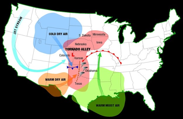 We humans have a thing for straight lines and steady, consistent patterns. Nature tends toward a more open, free flowing dynamic stability where patterns are consistent, within a range…lines bend and move. For example the chart here shows the conditions typically in play during the mid-west’s tornado season. The pattern itself is not fixed, varying with the strength and size of the approaching air masses, ‘stretched’ or pushed more easterly or not by the jet stream, sometimes well into the deep south. The tornados ‘propagate’ along the shared edge of the drastically different air masses. In nature the most dynamism is always find along edges. For us in the maritime PNW the typical winter jet stream, drives in from the west coast, pushing in heavy with water. Other times it ‘splits’ sending much of the rain north into BC and south into California, and we get a pass. That isn’t the norm, but what is normal when patterns are in flux? The flow of energy around the globe has a kind of momentum and tends to specific patterns, but can be pushed into new patterns, by changes in the energy it contains, even chaotic changes, before a new consistency is established. In other situations too much additional energy can be so disruptive that no consistent patterns develop…look at those in a pot of boiling water. Climate change, the addition of carbon in our atmosphere, will result in more frequent and larger perturbations shifting average to a new position. It has to. Energy, heat, is in continuous movement, moving from warm to cold, pushing wind and water, seeking stasis, a ‘goal’ which is unattainable because of the dynamics of the system, its constant gains and perpetual losses out to ‘space’. Adding or retaining more energy in any system can transform it. What is known and normal will shift.
