Clarno Formation – 54 to 39 million years ago.
Getting back to Central Oregon, the Clarno Formation formed much of the region’s base rock, an accumulation of volcanic rock, their sediments and soils in layers to as much as 6,000’ thickness. 6,000’. The area was what geologist call an ‘extensional basin’, a broad low basin between the Blues and Wallowa Mountains and the accreting and volcanic landscape forming to its west.
As the Clarno was forming so was Siletzia off the coast of Oregon, Washington and British Columbia, building up relatively rapidly from intense and volcanic activity between 56-49 million years ago to the west. Siletzia was then accreted to the continent due to plate tectonics. In Oregon this terrane became the area we now recognize as our Coast Range and Willamette Valley.
This area looked far different before this period than at its end. It looked far different again, from when it attained its maximum elevation, to how it appears today. Trying to tack all of this is a bit like trying to follow a 3 ring circus…with many more rings, all proceeding at the same time, with generous overlaps. When looking at our landscape we are faced with the problem of the never ending processes of ‘addition’ and erosive ‘subtraction’. The ‘end’ of the period we define as the Clarno Formation is not one of some final result. The regions canyons, have today been deeply eroded, cut steep, with broken slopes, below the rim tops we see today. These were very different 39 Ma and they will look far more different in another million or ten million years from today, likely unrecognizable to us. Even if we were able to somehow survive until then to observe them, our ‘snapshot’ and pliable memory of them would have likely transformed over the many centuries. Erosion will have been at work over the intervening time together with those forces working to ‘build’ and ‘lift’, the working of plate tectonics locally continuing to drive the process as they continue in their slow motion crashing, transforming the surface from below.
During the Clarno those forces continued with, explosive eruptions, lava and pyroclastic flows, lahars that poured down from volcanoes of the Mutton Mountains in the formations northeast corner and Ochoco Mountains area, just west and south of the Blue Mountains, along with their mudstone, and conglomerates derived from the erosion of both accreted terranes and that of volcanically ‘built’ structures. And thus was ‘built’ the Clarno and the later John Day Formation. The three largest volcanic structures of the period in the Ochocos remain today as the Crooked River, Wildcat Mountain, and Tower Mountain Calderas. These volcanos have not been active for many millions of years. The center of volcanic activity in the region began to shift westerly during the Clarno with the tectonic changes accruing to the expanding continent’s edge developing into what would be the Cascade Volcanic Arc. The Ochoco Volcanic Area remained an active factor on through the development of the John Day Formation Period. Continue reading →

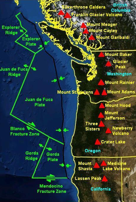 Over the last 2.5 million years, roughly corresponding with the Pleistocene Ice Age, there have been at least 1,054 volcanoes in a ‘belt’ from Mt. Hood running 210 miles south to the California border and then, after a break, continuing to Mt. Shasta and Mt. Lassen, in a band 16 to 31 miles in width. These latter two, southern most of the Cascades, show no effect of glaciation from Glacial Periods. They were far enough south of the Glacial Ice to be unaffected. The material ejected and flowing from these many volcanoes and vents come from the crustal material of the subducting Juan de Fuca plate. The Cascades are a defining feature of our region in terms of aesthetics, but also as a shaper of climate, as well as being a physical barrier limiting the movement of organisms and thus goes to determining the ‘shape’ of our lives here. The Arc is still active, magma is still being ‘delivered’, building incredible pressure below through these same processes which have shaped this place to date. While we may assess its various mountains as ‘active’ or not, the volcanic arc, is still very much a factor in determining our long term future. Where it will next erupt from, and what form that will take, is impossible to say within any degree of confidence. But the earth’s tectonic plates are still in movement. Magama is still slowly, but inexorably, coursing through its crustal layers and the movement and pressures will continue to result in further eruptions. Continue reading