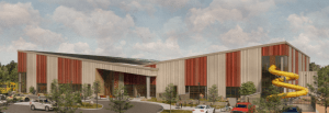
This is the rendering of the new facility’s south entry. It’s the banner on the RAPRD’s announcement of Novembers funding levy for the new facility.
Much of what I write of and post here are topics concerning ‘place’, its centrality to life, including our own. This post is specific and narrow, focusing on a non-gardening, non-horticulture, activity important in my life, swimming. I am recently turned 70 years old and their are many physical things I can no longer do and others I have had to modify, given my record of injuries and ‘weaknesses’ of my body particular to it. I have always ben physically active, craved movement and enjoyed the sensations of moving through ‘space’, of strength and competence, of engagement with….I would run, climb over things in my path, do things to prove that I could, explore the world in front of me; physically, and test that understanding. I enjoyed, and still do, the feeling of being ‘capable’. It is a necessity for me, just as is my mental engagement. It is of the same piece. As I age now, while my physical capacities have lessened, sometimes because of my past efforts, I, like a machine, have been wearing out. But, unlike machines, that physical activity, that stressing and testing of ourselves, allows us to stay capable and strong, a response within limits, to the stressing we subject ourselves to, as long as we get enough rest, have a healthful diet and recognize our own limits.’
I haven’t been able to run or participate in sports that require it, without significant consequence, for quite a few years now. The recognition of my own limits, lead me first to yoga, which I practiced regularly and incorporated into the physical movement of my daily work during my working years. While not ‘slavish’ to my practice, I still do this adding in some specifically core strengthening exercises. When, almost thirty years ago, a local public pool was significantly renovated, I began to lap swim, to help with my upper body and core strength as well as my flexibility. The demands of my work were such that if I didn’t do something, the physical demands of my work, which were greatly lessened during the continuous running around of summer, lead to a weakening of my upper body, just as I would be back to placing it under most demand. As I was aging my spinal anomaly was becoming an ever bigger limitation and I was looking about for solutions. I wanted to be able to continue my work in horticulture/parks and was afraid my career might end with me in chronic pain and incapable of doing the things that gave my life purpose and direction. I overcame the idea of boredom and tediousness of swimming face down in a pool lap after lap, as well as my unease with breathing while face down in water, and both my health and sense of well being improved. I still swim. It has become essential. I know what stopping for a significant amount of time means for me. So when we moved, having ready access to a pool was a top priority for me. We bought a home in a community with a lot on which I could garden, with a view of the Cascades and a pool…at least the promise of one. The pool has not yet been built. Continue reading →

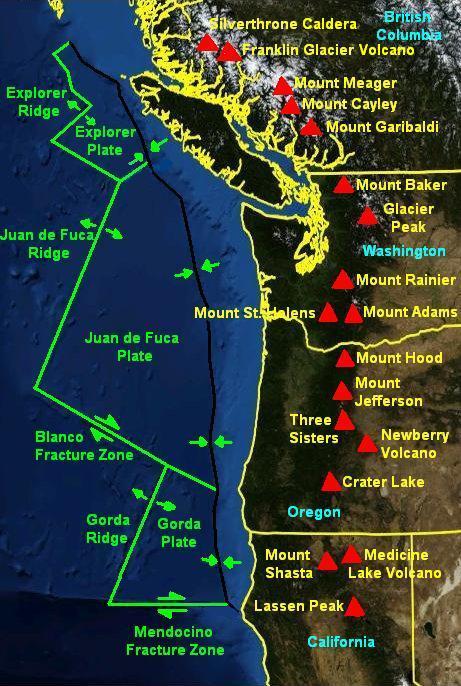 Over the last 2.5 million years, roughly corresponding with the Pleistocene Ice Age, there have been at least 1,054 volcanoes in a ‘belt’ from Mt. Hood running 210 miles south to the California border and then, after a break, continuing to Mt. Shasta and Mt. Lassen, in a band 16 to 31 miles in width. These latter two, southern most of the Cascades, show no effect of glaciation from Glacial Periods. They were far enough south of the Glacial Ice to be unaffected. The material ejected and flowing from these many volcanoes and vents come from the crustal material of the subducting Juan de Fuca plate. The Cascades are a defining feature of our region in terms of aesthetics, but also as a shaper of climate, as well as being a physical barrier limiting the movement of organisms and thus goes to determining the ‘shape’ of our lives here. The Arc is still active, magma is still being ‘delivered’, building incredible pressure below through these same processes which have shaped this place to date. While we may assess its various mountains as ‘active’ or not, the volcanic arc, is still very much a factor in determining our long term future. Where it will next erupt from, and what form that will take, is impossible to say within any degree of confidence. But the earth’s tectonic plates are still in movement. Magama is still slowly, but inexorably, coursing through its crustal layers and the movement and pressures will continue to result in further eruptions. Continue reading