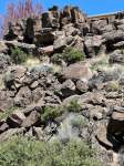
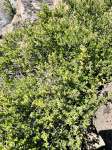
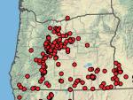
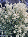
Category Archives: Parks

On Our Western Juniper Survey in Redmond’s Dry Canyon

This is an explanation of the importance of the survey work being done by the Friends of North Dry Canyon Natural Area, FNDCNA, and it’s role in the creation of a broader management plan, and a fire management plan, that addresses both community safety needs, as well as those of the Western Juniper and Sagebrush steppe plant communities in Dry Canyon. This is a 160 acre portion of the Canyon Park that stretches 3.7 miles, north to south, through the City, a remnant of one of the canyons formed by one of the previous courses of the paleo-Deschutes River, (There were at least two, one some distance east of Redmond’s location, joining with the Crooked River at present day Smith Rock State Park. The current Deschutes River flows 4 miles to the west of this location through a canyon carved in its earlier stages by Tumalo Creek.) Continue reading

Holodiscus microphyllus, Rock Spiarea in Dry Canyon

Another less common slope dweller is Holodiscus microphyllus, or Bush Ocean Spray, a deceiving name, or Rock Spiarea, which is also somewhat confusing. Confusing because Spiarea is the genus name for an entirely different genera of shrubs. So I call it simply Holodiscus. ( Botanical names can be confounding to the uninitiated. I’m not a big user of mnemonics, but I still remember first learning this plant’s close relative, Holodiscus bicolor, and the phrase immediately came to mind, ‘Holy Discus, Batman!” I know, silly, but I doubt I will ever forget that plant.)

This typically occurs on the eastern flank of the Cascades and in the mountains of SE Oregon. The common name, ‘rock’, suggests its preferred sites. I’ve not seen one in Dry Canyon bottomland. It seems most common below the east rim north of the Maple Bridge. Continue reading

That Gray Stuff? It’s All Sagebrush…Nope

Part of the Dry Canyon plant series

Everybody knows Juniper and I suspect that a lot of people who think they know Sagebrush, that ubiquitous gray shrub you see everywhere, may be confusing it with other plants, blurring all ‘gray’ shrubs into one. Now this may not seem to be a big deal, but if you are trying to manage a landscape with these in them or trying to create a landscape which reflects the local plant communities, then it becomes much more important that you know what you have so that you can evaluate your landscape’s condition and decide upon what you may need to do, or stop doing, to meet your goals. Continue reading

The Cut Leaf Thelypody in Dry Canyon

[Plants of the Dry Canyon Natural Area – This will be the start of a new series focused on the plants of Redmond’s Dry Canyon. I’m creating them to be posted for ‘local’ consumption on the Friends of North Dry Canyon Natural Area. It’s a City Park including about 166 acres at the north end of Dry Canyon Park which the City has identified as a Natural Preserve. The group works as an advocate with the City, on public education and helping with on the ground work projects. I’ll identify each such post here.]

As you walk the trails below the canyon rims you will be seeing these growing scattered and in bunches. This is the Cut Leaf Thelypody, Thelypodium lacinatum. These are common where ever there’s a bit of soil between the rocks on the slopes below the rims growing amongst the tumble of massive basalt. I’ve seen these elsewhere growing in other eastside Oregon canyons with similar conditions.
These are members of the Mustard family, prolific seed producers and quite competitive. Another plant that, at least so far, doesn’t venture out into the canyon’s bottomland.
Elegant when it first starts flowering, like so many native annuals and perennials, these start declining while they proceed through their flowering season detracting from their appearance. What do I mean…each spent flower, begins to form its narrow, linear, Mustard seed capsule, quickly maturing its tiny seed and then drying, twisting and browning, while the inflorescence continues to bloom out towards its terminal end. A little messy, yes, but characteristic of these plants. We humans are relatively intolerant of such decline in our garden plants and so generally refuse them admission. Under the local wild conditions, as dry as they are, species tend to either be early flowering, when soil moisture is still most available or those like this that begin to decline before the show is over. Summer drought is a ‘cruel’ taskmaster. There are exceptions to this rule but….

https://oregonflora.org/taxa/index.php?taxon=8778

Mowing Firebreaks Across the Dry Canyon Bottom, Good Idea or No?

Mowing weakens the native plant community and aids the growth of weeds.

Mown adjacent to unmown. Aggressive spreaders will fill in more quickly and because of the weeds already in place, they will sieze a larger proportion of the mown area as they grow and spread.

While recently walking home through the Canyon, last month in December, I noted 8 new  strips, presumably ‘fire breaks’, mown across relatively flat and uniform sections of bottomland, each maybe 50’+ wide, spanning the bottom between the paved eastern path and the the main dirt western bike path. While I understand the thinking here, removing ground level fuels, this is a single purpose treatment that works counter to the Park’s purpose as a natural area preserve. Mowing down the Rabbitbrush, a ruderal, transition species of the Sagebrush Steppe plant community, delays the development of a healthy native plant community and encourages an increased array and density of weeds and invasives. Mowing this way provides open space for weed species already in Dry Canyon, as well as those not yet here, giving them larger ‘launch points’ from which they can spread into the rest of the Canyon. Mowing weakens natives, which are naturally slower to rebound from the damage than the aggressive weed species. Continue reading

From 0’ – 3,000’ in 70 Million Years:  Building Oregon, Dry Canyon, The Shaping of Redmond and the Geology of the Paleo-Deschutes, Part 3

Cascade Volcanic Arc –

Over the last 2.5 million years, roughly corresponding with the Pleistocene Ice Age, there have been at least 1,054 volcanoes in a ‘belt’ from Mt. Hood running 210 miles south to the California border and then, after a break, continuing to Mt. Shasta and Mt. Lassen, in a band 16 to 31 miles in width. These latter two, southern most of the Cascades, show no effect of glaciation from Glacial Periods. They were far enough south of the Glacial Ice to be unaffected. The material ejected and flowing from these many volcanoes and vents come from the crustal material of the subducting Juan de Fuca plate. The Cascades are a defining feature of our region in terms of aesthetics, but also as a shaper of climate, as well as being a physical barrier limiting the movement of organisms and thus goes to determining the ‘shape’ of our lives here. The Arc is still active, magma is still being ‘delivered’, building incredible pressure below through these same processes which have shaped this place to date. While we may assess its various mountains as ‘active’ or not, the volcanic arc, is still very much a factor in determining our long term future. Where it will next erupt from, and what form that will take, is impossible to say within any degree of confidence. But the earth’s tectonic plates are still in movement. Magama is still slowly, but inexorably, coursing through its crustal layers and the movement and pressures will continue to result in further eruptions. Continue reading

Redmond’s New Community Center/Pool and the Anti-Government Bias: This is What Community Failure Looks Like

This is the rendering of the new facility’s south entry. It’s the banner on the RAPRD’s announcement of Novembers funding levy for the new facility.

Much of what I write of and post here are topics concerning ‘place’, its centrality to life, including our own. This post is specific and narrow, focusing on a non-gardening, non-horticulture, activity important in my life, swimming. I am recently turned 70 years old and their are many physical things I can no longer do and others I have had to modify, given my record of injuries and ‘weaknesses’ of my body particular to it. I have always ben physically active, craved movement and enjoyed the sensations of moving through ‘space’, of strength and competence, of engagement with….I would run, climb over things in my path, do things to prove that I could, explore the world in front of me; physically, and test that understanding. I enjoyed, and still do, the feeling of being ‘capable’. It is a necessity for me, just as is my mental engagement. It is of the same piece. As I age now, while my physical capacities have lessened, sometimes because of my past efforts, I, like a machine, have been wearing out. But, unlike machines, that physical activity, that stressing and testing of ourselves, allows us to stay capable and strong, a response within limits, to the stressing we subject ourselves to, as long as we get enough rest, have a healthful diet and recognize our own limits.’

I haven’t been able to run or participate in sports that require it, without significant consequence, for quite a few years now. The recognition of my own limits, lead me first to yoga, which I practiced regularly and incorporated into the physical movement of my daily work during my working years. While not ‘slavish’ to my practice, I still do this adding in some specifically core strengthening exercises. When, almost thirty years ago, a local public pool was significantly renovated, I began to lap swim, to help with my upper body and core strength as well as my flexibility. The demands of my work were such that if I didn’t do something, the physical demands of my work, which were greatly lessened during the continuous running around of summer, lead to a weakening of my upper body, just as I would be back to placing it under most demand. As I was aging my spinal anomaly was becoming an ever bigger limitation and I was looking about for solutions. I wanted to be able to continue my work in horticulture/parks and was afraid my career might end with me in chronic pain and incapable of doing the things that gave my life purpose and direction. I overcame the idea of boredom and tediousness of swimming face down in a pool lap after lap, as well as my unease with breathing while face down in water, and both my health and sense of well being improved. I still swim. It has become essential. I know what stopping for a significant amount of time means for me. So when we moved, having ready access to a pool was a top priority for me. We bought a home in a community with a lot on which I could garden, with a view of the Cascades and a pool…at least the promise of one. The pool has not yet been built. Continue reading

The Much Maligned Western Juniper: The Role of Juniperus occidentalis in Central Oregon

Old growth Junipers near Cline Buttes. These two rooted down long ago on top of this lava flow. Much of the lavas here were produced during the Deschutes Formation over many thousands of years more than 5 million years ago. Surface lavas, cliffs and slopes define the area with a few sediment filled basins dominated by Sagebrush and Bitterbrush.

The Western Juniper is the  singular native tree of Dry Canyon and the immediate Redmond area. I grew up with it here in Central Oregon. When we moved here in ’61 i remember driving north after passing through miles and miles of various Pine forests, which eventually yielded, riding in our VW bus, as we left Bend. Bend sits within the ecotone, the relatively narrow transition zone, between Ponderosa Pine forest and Juniper steppe. What were these trees? Coming from California’s Salinas Valley, the landscape could hardly be more different to a six year old. So different in form and detail, Junipers squatted darkly across the landscape, nothing like the tall, majestic Pines or Oaks I was more familiar with or even the Lodgepole Pine we drove through across the pumice plain of the LaPine area. Continue reading

Weeds, Weeding and the Health of Our Public and Private Landscapes: an example from the ‘hood

Every gardener is a weeder. Gardens are created landscapes, often expressions of the individual gardener or, lacking of intent and design sense, those of a chosen designer. We live in our landscapes as active, responsible, creators, participants and stewards. Gardeners are trying to create a particular look or to grow particular plants native to their area, or with ornamental value or food plants to feed themselves and their families. Some of us are simply pursuing what we understand to be a healthy relationship with one’s place, to undo the damage and allow a new healthy and vital landscape to grow. These are landscapes of our choice. Our intention and control results in various volunteers and weeds finding their own place and so follows the need for weeding. 

We watch carefully, monitor the impacts of our work, attempt to understand what result is moving us closer to our goal and which might be indicators of further loss. Landscapes and gardens are incredibly complex systems and anyone who claims to have all of the answers is fooling himself and you. Our landscapes are broken, by us and our predecessors. The Pandora’s Box of weeds and disruption was burst open long ago. The only way ahead is to find a new path.  Weeds are here filling the niches we have collectively made and maintain for them. The more one is surrounded by aggressive, well adapted weeds, the more time we must spend controlling them. While this can be significant, gardeners mostly take the work in stride, a necessity to reach our goal, a goal which may be the simple act itself, of working in concert with our place…open to its teachings. Gardening, is a way of life, a smaller scale version of farming and the management of large ‘natural areas’ with their attendant commitment, rhythms and demands. Continue reading

The Flushing/Testing of Redmond’s New Municpal Well Into Dry Canyon’s Natural Preserve

This shows the effected portion of Dry Canyon Park from Antler, at the bottom, where the new municipal well is located, north to the Maple St. Bridge. The Fir connector trail shows up faintly cutting diagonally across the canyon from Fir Ave, 3 blocks north of John Tuck School. West Canyon Rim Park is labelled on the the left. The trail/dam cuts up, northeasterly from it, gray as it is asphalted, faintly in the pic. The water travelled 200 yds north of it, a bit short of halfway up to the Maple Bridge.

I’ve adopted Redmond’s Dry Canyon Park as a project, so I’ve gotten kind of possessive about things that threaten and effect it…but it is a City Park and cities often have competing demands and priorities. In this case the City is under considerable pressure to keep growing. People and businesses are still arriving here at a high rate and this puts demands on its public infrastructure, in this case its water supply. A city of its size also finds itself in need of more Park lands as people’s private space shrinks, population density increases and we all turn to the same limited landscapes for recreation. Compound this with the demand of wildlife and plants for relatively undisturbed landscapes on which they can simply live. Well, this is a case where two of these priorities have come into conflict, and as usual, the utilitarian demands have won out over those for the living natural world (There is no division of the City or local advocacy group, at this point, speaking up for the natural landscape and the life it supports). The utilitarian ‘needs’ of the community are simply a higher priority than those of the natural world. The State is responsible for our water resource and has control over adding new wells and how that is to be done. It is in at least part a health and safety issue. In this role they require that municipalities flush the wells and conduct a flow test to determine rate, drawdown and recovery. This was to be done by running it at full volume 24 hours a day for four days. At 3,500 gals./min. That’s 5 million gals per day. 20 million gals total. That water must go somewhere. It would have overwhelmed our wastewater treatment plant which is running at close to capacity already so it couldn’t be wasted down a manhole…so, it had to be wasted into the landscape of the Canyon itself.

The City contested this amount. This is almost double the amount used by by all residents on a typical winter day of 2.7 million gallons (In summer, due to landscape irrigation the daily amount jumps to 15.8 million gals.). This was all to be ‘wasted’ across the canyon floor. The City had concerns with damage to area infrastructure and paved paths. This requirement was cut in half and eventually to a single 12 hour period as the flooding/washing problem played out. The amount flushed was 2.5 million gals.

April 14, 2024

The filling ‘reservoir’ abutting the north path.

I was unaware of the details of this as I walked the stretch of path this afternoon  going north along the west side dirt path, from the trail connector between the main paved trail, extending from the Fir Ave. stairs. I was surprised at all of the surface erosion on and around the dirt path. In some places a foot or more of path had been scoured away, flushed out into the surrounding landscape, its Bitterbrush, Rabbitbrush and other low plants. This erosion continued north following the contours and the trail.

The northern extreme of the test run, where the flow slowed and settled all of the light organic debris.

As the flow spreads and slows larger denser material settles out. Here sediment was deposited in the trail itself and on the ground where the water fanned out.

The flooding had continued a couple hundred yards to where the flow stopped depositing a layer of organic debris the water had carried along.

(I learned on the 17th that this was the result of a test to see what kind of damage might occur and to gauge how the water would spread across the site. This is why the crew was there on the 17th. The test was an attempt to determine the flow pattern so that they could minimize damage.) Continue reading